

The Peak-2-Peak Adventure Run is a two-hour timed orienteering event hosted annually by Dontgetlost Adventure Running.
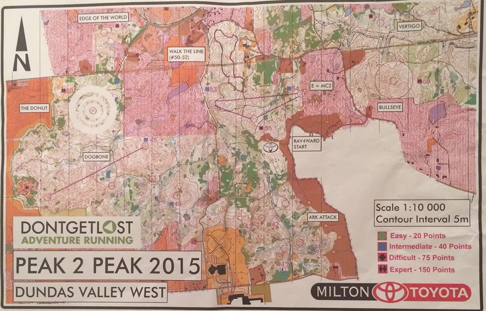
This race is organized on challenging terrain with lots of climbing with control checkpoints on the top of hills and ridges. The venue for the October 25th race was the Dundas Valley Conservation Area in Ancaster near Hamilton.
The course is a ‘Choose Your Adventure Run’ format where participants have two hours to get as many of the 20 checkpoints and score as many points as possible. The order and difficulty of the checkpoints you visit is up to you. Controls are colour rated by difficulty depending on the running and navigation skills needed to find the checkpoint. Green squares (easy) were 20 points, Blue squares (intermediate) were 40 points, Black Diamonds (difficult) were 75 points, and Double Black Diamonds (expert) 150 points.
Before the start, each racer got a 1:10,000 scale map showing places in the Dundas Valley trail system where the orienteering flags or controls (CPs) were located. An electronic SportIdent (SI) timing chip puncher is used to record each control visit. The map has a contour interval of 5m and at first glance (and maybe second glance!) looks confusing and jumbled. Being able to decipher map symbols and count contour lines either for ascent or decent to judge severity of elevation change helps you a lot.
I wanted to do this race on my own to practice solo map and compass navigation. And not try to follow other people on the course which is an easy trap to fall into. I was late getting to the race and that cut into time prepping a route of attack. In overall review take more risk. I should have attempted more black controls and skipped some of the easier green controls at the start.
Equipment:
Trail Running Shoes
Long-sleeves and racing pants. It was a chilly morning and you would be bushwhacking.
Watch to ensure that you return within the two-hour time limit
Whistle and Cell Phone in case you run into trouble
Compass. Useful for quickly finding which direction is north and taking map bearings.
1L of Tailwind hydration.
Pen/Marker to mark a route and make notes on the map
Running pack. Used my Duthie 10L I use usually for short to medium length runs and bike rides.
Race Summary:
There was a mass start on the field beside the Ancaster Community Centre at 10:15am.
I went for the ARKfest Attack area green checkpoints first.
41, 20p, 4:35 (4:35)
42, 20p, 1:01 (5:36)
43, 20p, 6:49 (12:25)
44, 20p, 4:35 (17:00) (then spooked a raccoon going for 45!)
45, 20p, 11:47 (28:47)
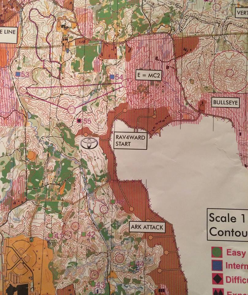
Then headed north for the three checkpoint triangle known as E=MC2. Two are blue and one is a black checkpoint and all have to done together before attempting any other controls.
55, 75p, 11:03 (39:50)
54, 40p, 9:16 (49:06)
53, 40p, 7:55 (57:01)
At this point the race time was about half over. I was reading the map to decide where to go next and three spooked, wide-eyed deer charged through. Hello! No doubt due to all the racers in the conservation area.
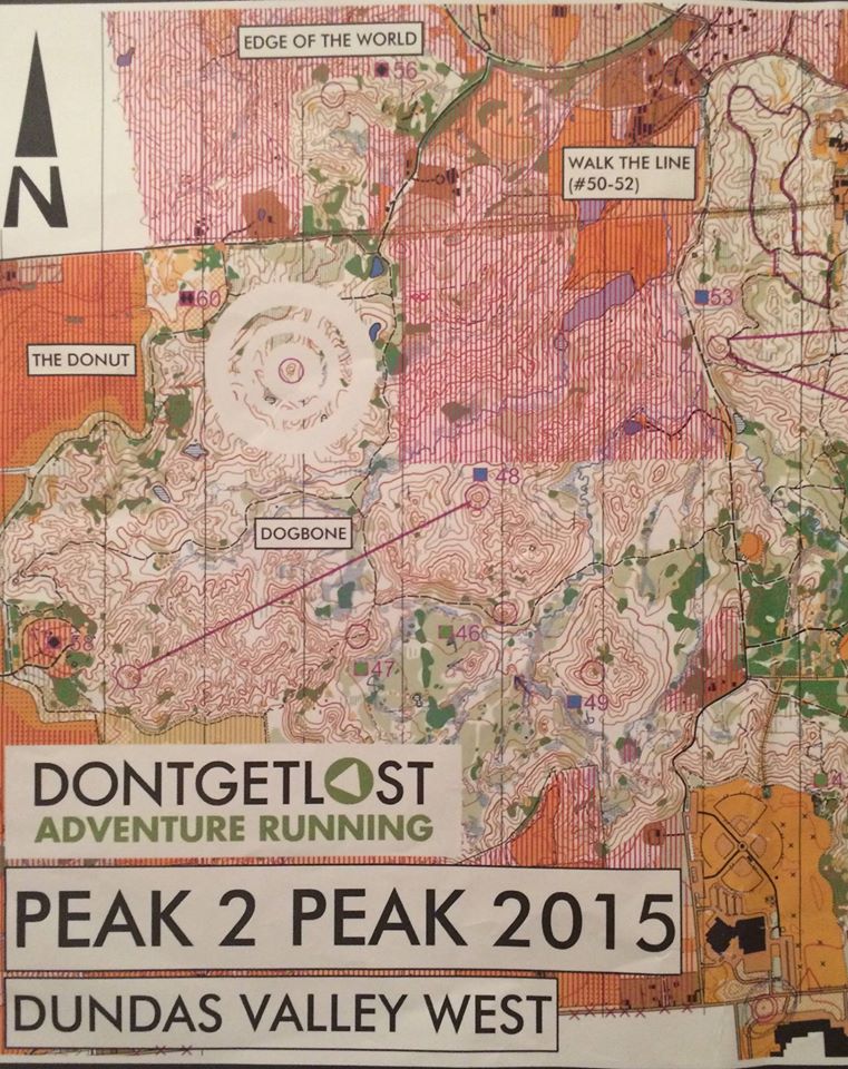
The decision was go west along the main Headwaters trail to two green checkpoints.
46, 20p, 11:06 (1:08:07)
47, 20p, 4:46 (1:12:53)
Then attempt the ‘Dogbone’ stage where two checkpoints have to be done in order, or as a pair. The first one I took a compass bearing and was not trying to copy/follow another team right in front of me.
58, 75p, 11:18 (1:24:11)
Before bushwhacking into the forest and checking for a bearing for checkpoint 48, I saw I had about 25-27 minutes left in the allotted two race hours.
48, 40p, 15:47 (1:39:58)
Now 20 minutes to get to the finish line.
So I bushwhacked out and sprinted back to the finish line at Ancaster High School taking the main trails. Enroute I passed eight horses on the Headwaters trail just to make life more interesting. This meant running up the infamous Martin Road southbound, the same challenging climb the annual Paris to Ancaster bicycle race ends on after cycling 70km!
Final result was 19th/55 for the open males category or 400 points. I finished the course in just two hours which is important because of the incentive to finish. You lose 10 points for every minute, or part of over the 2-hour time limit. The final result said I was 6 sec over, so assuming 5 points were deducted of my total.
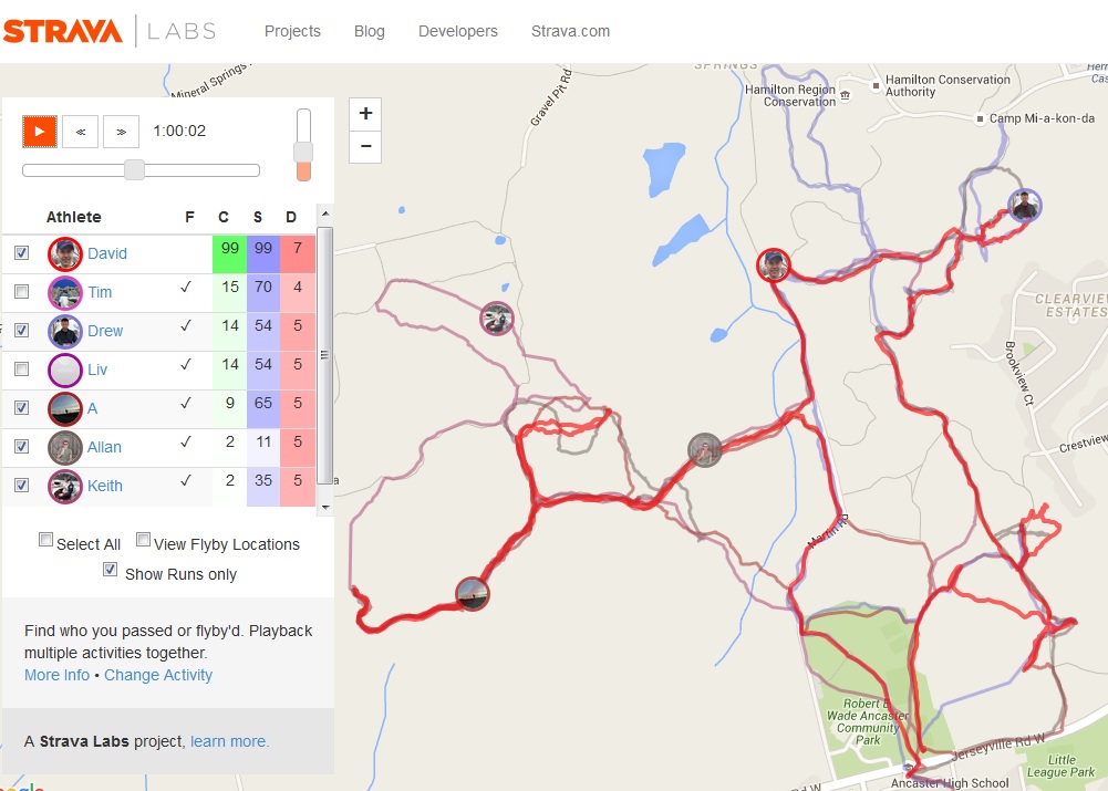
To give an idea of what choose your adventure run means on a map, I tracked the race on Strava. This image shows four other racers in different parts of the Dundas park halfway (or 1 hour) through the race going for different controls. The dark red line is my route and I’m in the centre with the blue cap and just finished CP 53.
A fun two hours for sure and a great workout climbing and descending all the peaks and ridges!
More Info:
More about the sport of orienteering – https://en.wikipedia.org/wiki/Orienteering


Congratulations on your awesome finish! Can you comment on the technical navigation skills for this race compared to Wilderness Traverse, Stars, or any other event you’ve participated in?
For this race I think the most important thing is allowing for time to study the map before the mass start and plan a logical route. This means annotating the race map with a black marker and highlighter and write down step by step instructions or notes on the map. So the order of controls points you plan to attack, direction of contours, number of contours, label compass bearings on the map and estimated time for each control. If I had more time before the start to plan these route details, I would have gone for the black diamond controls first.